Project GeoScape
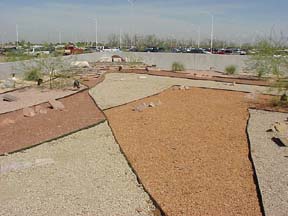
Project GeoScape is a landscape design that uses colored gravels, strategically placed flagstone and boulders, and two vertical features to simulate the geology of some fictitious region (a combination of features in Utah, Arizona, and Nevada). The design incorporates many topographic and geologic features that introductory geology students are expected to understand in Physical Geology, Historical Geology, and Natural Disasters & the Environment courses. GeoScape is an educational tool to promote "hands-on", inquiry-based, and cooperative learning techniques in the instruction of geology. It is intended to serve as a resource for the local educational community. It further hoped that the aesthetics of the GeoScape landscape will stimulate interest in geologic studies in the community at large. Read the GeoScape article published in the Journal of Geoscience Education.